Met Office
|
|
November 2024: a month of two halves
November 2024 feels like a month of two halves. Mild, dry and gloomy at first, then storms, snow and heavy rain to close.
Although no significant UK records have been broken, there’s been plenty going on with the weather this month.
A mild, dry and gloomy start
We started the month talking about the ‘anticyclonic gloom’. Two weeks of grey skies caused by high pressure trapping a low-level layer of cloud meant that some parts of the country recorded no sunshine at all during the first week of November. It wasn’t doom and gloom for everyone though, with northern and eastern Scotland experiencing more sunshine than others.
And along with the sunshine, Scotland also experienced far higher than average temperatures at the start of the month, with the village of Kinloss in Moray reaching 17.9°C on 7 November thanks in part, to the Foehn effect.
Northern Ireland too had a particularly mild start to the month. The daily minimum temperature at Magilligan, County Londonderry on the 7 November was just 0.3°C short of the highest minimum temperature for Northern Ireland ever recorded in November, which stands at 14.5°C.
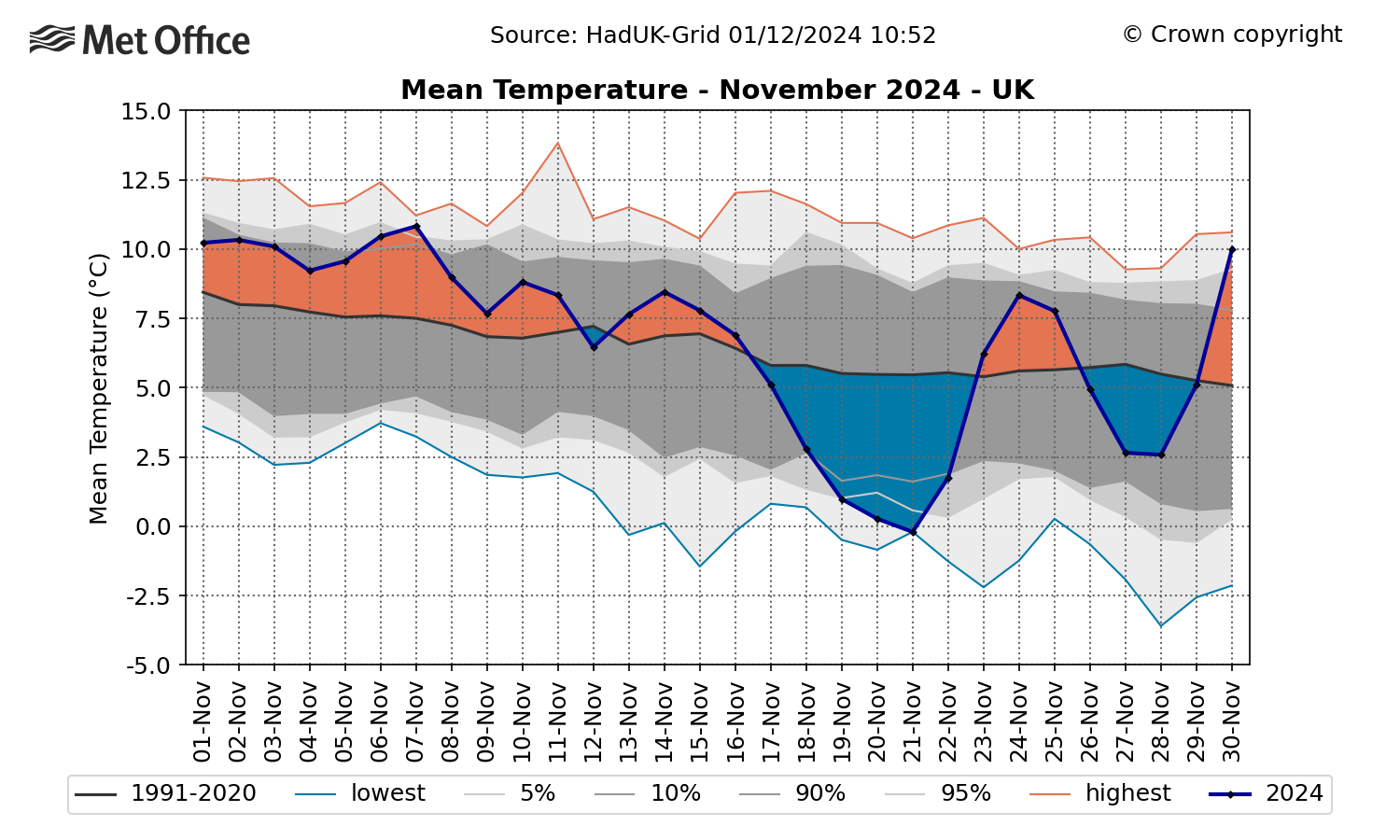
The first half of the month was indeed mild for all, with the UK recording a provisional average mean temperature of 8.8°C, which is 2.3°C above the long-term meteorological average, by the 16th.
For this period, Scotland and Northern Ireland were particularly warm, recording anomalies of 3.0°C and 3.2°C above the November average respectively.
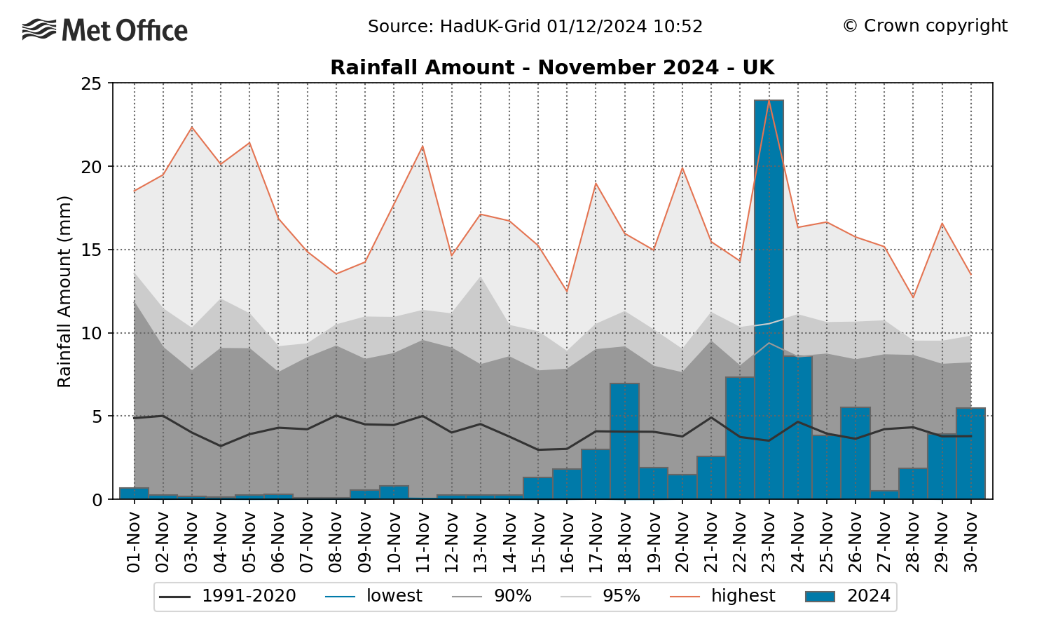
Along with sunshine, rainfall too was in short supply, with none of the UK’s countries recording more than 10% of their average rainfall by mid-month.
The below map shows the very dry start to November 2024, followed by heavy rain later in the month.

A cooler, wetter and windier end
By mid-month, lower pressure moved in bringing an Arctic maritime airmass and a major change in weather type. Temperatures fell and an unsettled period with snow and heavy rain followed.
Snowfalls on the morning of the 21 November to southern coastal counties resulted in lying snow as far south as Exeter, while there was already fairly extensive cover across Wales, the south Pennines and parts of central England. This brought the most significant spell of November snow to the UK since November 2010.

Storm Bert brings heavy rain and winds
A deep area of low pressure, which was named Storm Bert, then brought a spell of extremely wet and windy weather to large swathes of the country from 22 to 25 November. Although some impacts were reported from the strong winds and snow, the heavy rain brought the greatest impacts, with localised flooding in all regions of the UK.
The weekend was exceptionally wet across South Wales and south-west England, with more than 150mm falling in the wettest upland areas. Around three-quarters of the whole-monthly average rainfall fell in a swathe from Gwent to Wiltshire to Northamptonshire. The UK recorded its wettest calendar day – as an average across the whole country – since 3 October 2020.
Read more about Storm Bert in our event summary.
Click here for the full press release
Original article link: https://www.metoffice.gov.uk/about-us/news-and-media/media-centre/weather-and-climate-news/2024/november-and-autumn-2024-stats


.png)